
Chiemgau Alps: Around Högl mtb - Sept 19
We often see church in Anger from the highway as we ride to Munich. It is nicely light during the night. We went to explore trails above Anger - around Högl. The trail is in 8 figure, you go up and down from different side of the hill.
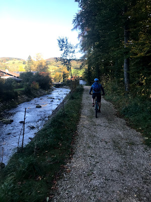
Höglwörther See is our starting point. We crossed Anger village with its beatufil church and we turned towards Högl peak. The ascending is not that steep as it goes zig-zag. We arrived to the highest point in less than 40 minutes. There is Strobalm but it was closed already, only few people walking around, enjoying the scenery. We entered the forest and the first part of trails starts right after. These are XC trails, you go up and down on the forest road (S0). It continues until we reached other-side of the hill. We are close to German-Austrian border. We could see Salzburg valley. We turned to left to start climbing back. This is the surprising part, the climbing back was on singletracks (they were wet, lot of roots - fun to ride even up but as the earlier descent was much easier, I would rather go down here and up there). We had to push our bikes for a bit as we also chose a “forgotten” trail (there are multiple choices here, other trails could be better, not having trees blocking the way). I did not remember reading the description of these trails otherwise we would have been going down here. As we arrived back to the crossroad below to Högl (there is a cross here), we turned right and continued through multiple forests toward Anger via trails (S1).
I would rate today as most of the way it is on S0 and that second part (both climb and descent) was on S1. There were possibly S2 trails we found around. We will return but we will definitely switch the second part of the figure 8 as described above: descent via singletracks and climb back up via XC trails.


Tour info
- Start
- Parking lot at Höglwörther See, free
- Duration
- 2:30 hours


